
Tactical Maps – Police RMS Software for Proactive Policing
Records management system (RMS) software is an integral part of every law enforcement agency’s operations. But beyond filing reports and storing citations, RMS technology can support agencies in proactively preparing for emergencies. Specifically, law enforcement agencies can use their RMS to store tactical maps and documentation for emergent situations.
In this blog, we’ll dig into how law enforcement agencies can use their everyday RMS software to store tactical emergency plans. Additionally, we’ll explore the importance of digitizing emergency response plans and how cloud-based software can ultimately keep both your community and officers safer.
Let’s begin.
Tactical Maps and Emergency Response Plans in Your RMS
There are a variety of ways that law enforcement agencies can store emergency response plans directly in their RMS. Here are some key functionalities your agency can utilize in your existing RMS software, or look for when researching a new RMS.
Leverage Your Master Index – Locations
Every RMS has a Master Index that stores information across reports, such as Persons, Locations, Vehicles, and more. Depending on the Master Index your system has, information can be connected in many useful ways.
For storing tactical maps and emergency response plans, use the Locations index within your Master Index to build out detailed profiles for locations that necessitate safety plans, such as hospitals, schools, university campuses, and the like.
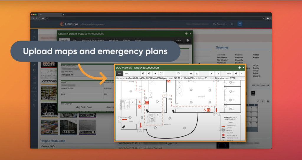
Within an advanced RMS, users can attach PDF files, photos, and more, all to a single location in the Locations index within the larger Master Index.
By attaching important critical files and information (which we’ll explain below), officers can find all they need by searching and clicking on a location’s profile.
Link Incidents and Locations
As you build out profiles of locations within your RMS, advanced RMS software will populate all past incidents that are linked to a location.
Whether building an emergency response plan or actively responding to an emergency, reviewing historic and/or recent incidents can equip officers with vital intel to inform their response tactics.
So, as your agency simultaneously creates detailed incident reports and builds out your Locations index, officers will continue to have greater access to vital information to shape tactical responses.
Upload Tactical Maps and Emergency Plans
As mentioned earlier, advanced RMS software enables users to upload PDF files directly to specific locations in your RMS. Agencies can utilize this feature to upload schematic diagrams, contingency plans, emergency action plans, and more.
By storing these in your agency’s RMS, officers can access them instantly. This is all by reviewing files attached to a location in the larger Master Index.
With a cloud-based records management system, officers can locate this information on-the-go, anytime, anywhere. This is critical when responding to emergency situations. Officers don’t have time to return to department buildings to retrieve physical emergency response plans.
Store Drone Footage and Layout Photos
Alongside maps and schematic diagrams, agencies can leverage advanced RMS software to upload photos of critical entry points, exit routes, hallways, and more of a specific location.
Additionally, system users can attach video footage, such as drone footage. This equips responding officers with a better overview of the geographic features and layouts of buildings or locations.
Document Landing Zones and Triage Areas
After documenting and attaching the files above, it’s important to include maps that designate landing zones and triage zones in your RMS. By including these documents, officers have access to important plans that streamline medical responses and landing locations for responding helicopters and other first responders.
Benefits of Tactical Maps
By using your agency’s RMS to prepare for emergency situations, your agency can contribute to the overall safety of both your community and your officers.
Read more below about the key ways in which tactical mapping in your RMS can benefit your agency and city.
Increase Situational Awareness
Primarily, having quick, accessible documentation for emergency response plans improves officers’ situational awareness. With improved situational awareness, officers can respond more efficiently and effectively with a more holistic understanding of a scenario.
Minimize Situational Paralysis
When a crisis occurs, officers don’t have time to shuffle through physical files or dig for emergency response plans. By storing your emergency response plans in a highly searchable RMS, officers can consult agency plans instantly. As a result, officers can respond with confidence and defer to protocols, instead of relying solely on their decision-making in a crisis scenario.
Promote Officer Safety
By minimizing situational paralysis, officers can respond more quickly and assuredly. Instead of making plans in real-time, officers can follow strategic protocols that will keep them, and the victims involved, safer.
Takeaways – Tactical Maps in RMS Software
RMS technology can help agencies better store and access their emergency response and tactical mapping plans. By storing tactical maps and strategic plans in your records management system, your officers can respond to critical incidents faster and more efficiently.
To learn more about the latest records management software and how systems like CivicRMS can support your agency’s tactical operations, click below to learn more.
GET IN TOUCH
To learn more about CivicRMS and schedule a demo, click here.
STAY IN THE LOOP
Follow CivicEye on LinkedIn – Facebook – Instagram – Twitter – YouTube.